Earth Science worksheet
    Topic: Plate Tectonics
    Plate Tectonics
    1

    A ship is at a location of 40° S 77° W. Which type of surface ocean current and tectonic plate boundary are located beneath this ship?

    (1) warm ocean current and a transform boundary

    (2) warm ocean current and a convergent boundary

    (3) cool ocean current and a transform boundary

    (4) cool ocean current and a convergent boundary

    2

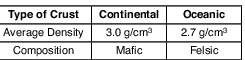
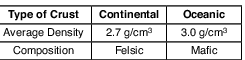
    Which table correctly matches the average density and composition of continental and oceanic crusts?

    (1) dynamic-earth, plate-tectonics, standard-1-math-and-science-inquery, changing-length-of-a-shadow-based-on-the-motion-of-the-sun fig: esci-v202-exam_g19.png

    (2) dynamic-earth, plate-tectonics, standard-1-math-and-science-inquery, changing-length-of-a-shadow-based-on-the-motion-of-the-sun fig: esci-v202-exam_g20.png

    (3) dynamic-earth, plate-tectonics, standard-1-math-and-science-inquery, changing-length-of-a-shadow-based-on-the-motion-of-the-sun fig: esci-v202-exam_g21.png

    (4) dynamic-earth, plate-tectonics, standard-1-math-and-science-inquery, changing-length-of-a-shadow-based-on-the-motion-of-the-sun fig: esci-v202-exam_g22.png

    3

    The photograph below shows a portion of the San Andreas Fault in the western United States.

    reference-tables, tectonic-plates, dynamic-earth, plate-tectonics, standard-1-math-and-science-inquery, changing-length-of-a-shadow-based-on-the-motion-of-the-sun, standard-6-interconnectedness, models fig: esci-v202-exam_g23.png

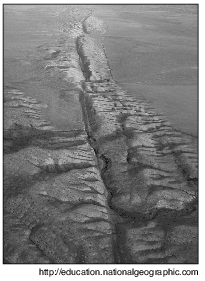
    The San Andreas Fault is an example of a

    (1) transform plate boundary

    (2) divergent plate boundary

    (3) convergent plate boundary

    (4) complex plate boundary

    4

    Which world map shows the locations where most earthquakes and volcanoes occur on Earth?
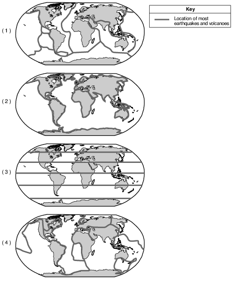
    reference-tables, tectonic-plates, dynamic-earth, plate-tectonics, standard-6-interconnectedness, models fig: esci12012-examw_g22.png

    (1) 1

    (2) 2

    (3) 3

    (4) 4

    5

    The arrival time of the first earthquake P-wave at a seismograph station was 10:11:20 (hours:minutes:seconds). If the epicenter of the earthquake is 8000 km away, what was the approximate arrival time of the first S-wave from this earthquake?

    (1) 10:02:00

    (2) 10:09:20

    (3) 10:20:40

    (4) 10:32:00

    6

    The diagram below represents the intensity of the shaking that occurs on different Earth surfaces during the same earthquake.

    dynamic-earth, plate-tectonics, standard-6-interconnectedness, models fig: esci12013-exam_g12.png

    The greatest earthquake hazard to homes exists when they are built on

    (1) hard igneous rock

    (2) sedimentary rock

    (3) coarse sediments

    (4) silt and mud

    Base your answers to questions 7 on the block diagram below, which shows a tectonic plate boundary.

    reference-tables, tectonic-plates, dynamic-earth, plate-tectonics, standard-6-interconnectedness, models fig: esci12013-exam_g11.png

    7

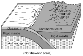
    Which tectonic plate boundary is best represented by this diagram?

    (1) Nazca Plate and Pacific Plate boundary

    (2) Scotia Plate and South American Plate boundary

    (3) Juan de Fuca Plate and North American Plate boundary

    (4) Antarctic Plate and Indian-Australian Plate boundary

    Base your answers to questions 8 on the passage below.

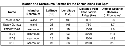
    Crustal Activity at Mid-Ocean Ridges

    Mid-ocean ridges are found at one type of tectonic plate boundary. These ridges consist of extensive underwater mountain ranges split by rift valleys. The rift valleys mark places where two crustal plates are pulling apart, widening the ocean basins, and allowing magma from the asthenosphere to move upward. In some cases, mid-ocean ridges have migrated toward nearby mantle hot spots. This explains why mid-ocean ridges and mantle hot spots are found together at several locations.

    8

    Which type of tectonic plate boundary is located at mid-ocean ridges?

    (1) convergent

    (2) transform

    (3) divergent

    (4) complex

    Base your answers to questions 9 on the passage and map below and on your knowledge of Earth science. The map shows the locations of the Mt. Redoubt volcano and Anchorage, Alaska.

    Mt. Redoubt Volcano

    In Anchorage, Alaska, scientists are monitoring sensors located on nearby Mt. Redoubt. The sensors measure seismic activity at the top of the volcano. No one lives near the volcano itself, so there is no danger to humans from lava flows, but ash can be dangerous when breathed in, and can damage airplanes and automobiles if the ash is drawn into their engines. When Mt. Redoubt erupted in 1989, a huge ash cloud reached an approximate height of 7.6 miles above sea level, and spread ash across Alaska for five months. The ash was composed largely of silica, which cooled rapidly as the ash rose into the atmosphere. In March 2009, Mt. Redoubt erupted again.

    reference-tables, tectonic-plates, dynamic-earth, plate-tectonics, standard-1-math-and-science-inquery, changing-length-of-a-shadow-based-on-the-motion-of-the-sun, standard-6-interconnectedness, models fig: esci12014-examw_g24.png

    9

    Mt. Redoubt’s seismic activity is due to the interaction of which two tectonic plates?

    (1) Pacific Plate and Eurasian Plate

    (2) Eurasian Plate and North American Plate

    (3) North American Plate and Pacific Plate

    (4) Philippine Plate and Eurasian Plate

    Base your answers to questions 10 on the diagram and tables below. The diagram shows a rock sample containing fossils from a location in New York State at 42° N 78° 15⬘ W. Fossils 1, 2, 3, and 4 are labeled. Table A lists the names and rock types of the New York State rock units from the Middle and Late Devonian in this area. The presence of fossil 1, 2, 3, or 4 in a rock unit is indicated by an X in the fossils column in the table. Table B identifies typical rocks formed within different marine (ocean) environments.

    reference-tables, generalized-bedrock-geology-of-new-york-state, landscapes, patterns-of-deposition-and-formation-of-sedimentary-rocks, standard-6-interconnectedness, models fig: esci12013-exam_g37.png

    reference-tables, generalized-bedrock-geology-of-new-york-state, landscapes, patterns-of-deposition-and-formation-of-sedimentary-rocks, standard-6-interconnectedness, models fig: esci12013-exam_g39.png

    reference-tables, generalized-bedrock-geology-of-new-york-state, landscapes, patterns-of-deposition-and-formation-of-sedimentary-rocks, standard-6-interconnectedness, models fig: esci12013-exam_g38.png

    10

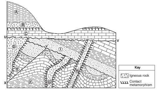
    Identify the landmass that collided with the eastern coast of North America to create the Acadian mountain range and the basin for the deposition of the Devonian rock units in table A. [1]

    Allow 1 credit for Avalon.

    Base your answers to questions 11 on the geologic cross section of Earth’s crust in image provided and on your knowledge of Earth science. Letters A through F identify rock units. Letter X identifies a fault. Wavy line YZ represents an unconformity. The locations of contact metamorphism and the map symbols for sedimentary rock layers B and E have been omitted.
    11

    On the cross section in the image provided, draw two arrows, one on each side of fault X, to show the relative direction of movement of the rock units that occurred during faulting. [1]

    dynamic-earth, plate-tectonics, standard-6-interconnectedness, models fig: esci12014-ansbk_abkq3.png

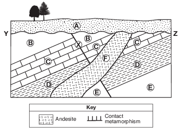
    Allow 1 credit if two arrows are correctly drawn approximately parallel to the fault, showing the relative motion, as shown.

    • Note: Allow credit even if the arrows extend through rock F.

    • Do not allow credit for any arrow in layer A, only.

    Base your answers to questions 12 on the passage and geologic cross section below and on your knowledge of Earth science. The geologic cross section represents rock layers of a portion of the Niagara Escarpment, and landscape features that are found in the Niagara region. The rock layers have not been overturned.

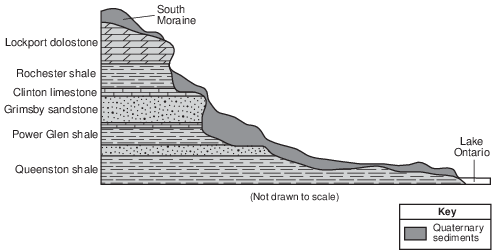
    The Niagara Escarpment

    A prominent feature found along the shore of Lake Ontario in western New York State is the Niagara Escarpment. This escarpment is the remains of an ancient seabed that was formed when the area was covered by a warm, shallow sea from approximately450 to 430 million years ago. Erosion of the Taconic Mountains to the east provided

    the sediments deposited in this basin area. From these sediments, rock layers such as shale, sandstone, and limestone formed. Later, magnesium replaced some of the calcium in the top layer of limestone, turning it into a dolostone layer. When the high ocean levels of the Ordovician Period dropped, the draining of this inland sea caused unequal erosion of the exposed layers. The South Moraine was deposited on the top of the Niagara Escarpment in this region.

    reference-tables, generalized-landscape-regions-of-new-york-state, landscapes, development-of-landscape-features, standard-1-math-and-science-inquery, changing-length-of-a-shadow-based-on-the-motion-of-the-sun fig: esci12017-examw_g35.png

    12

    Describe the tectonic event that caused the Taconian orogeny. [1]

    Allow 1 credit. Acceptable responses include, but are not limited to:

    • — the collision between North America and a volcanic island arc

    • — closing of the western part of the Iapetus Ocean

    • — crustal uplift

    • — convergence

    Base your answers to questions 13 on the cross section of part of Earth’s crust in image provided and on your knowledge of Earth science. On the cross section, some rock units are labeled with letters A through I. The rock units have not been overturned. Line XY represents a fault. Line UV represents an unconformity.
    13

    On the cross section in the image provided, draw two arrows, one on each side of line XY, to show the direction of relative movement that has occurred along the fault. [1]

    dynamic-earth, plate-tectonics, standard-1-math-and-science-inquery, geocentric-model-heliocentric-model, standard-6-interconnectedness, patterns-of-change fig: esci82014-ansbkt_abkq1.png

    Allow 1 credit for one arrow pointing downward on the left side of line XY and one arrow pointing upward on the right side of line XY.

    • Example of a 1-credit response:

    dynamic-earth, plate-tectonics, standard-1-math-and-science-inquery, geocentric-model-heliocentric-model, standard-6-interconnectedness, patterns-of-change fig: esci82014-rg_g1.png

    Base your answers to questions 14 on the map in image provided, on the table below, and on your knowledge of Earth science. The map shows a portion of the Nazca Plate under the southeastern Pacific Ocean. Plate A represents another tectonic plate. The table shows some data for islands and seamounts (undersea volcanoes that do not rise above the ocean surface) that originally formed at the Easter Island Hot Spot.

    dynamic-earth, earth-surface-features, landscapes, standard-1-math-and-science-inquery, eccentricity-rate-gradient-standard-error, standard-6-interconnectedness, models fig: esci-v202-exam_g44.png

    14

    Identify the name of tectonic plate A. [1]

    Plate

    Allow 1 credit for Pacific Plate.

    Base your answers to questions 15 on the passage and map of a portion of the East African Rift system shown below. Point X represents a location on Earth’s surface within a rift valley on the Ethiopian Dome.

    The Great Rift Valley

    Rifting of Earth’s crust in eastern Africa began during the Neogene Period as the Ethiopian and Kenyan Domes formed. These two huge domes were created as Earth’s mantle pushed up the overlying crust. As the crust was forced upward, the resulting tension cracked the crust, resulting in the eruption of volcanoes and the formation of large rifts. The crust continued to pull apart, forming rift valleys. These valleys have become deeper and are currently becoming filled with sediments, igneous rock, and water.

    geologic-history, reference-tables, earth-history, earth-history, relative-age-and-sequence-of-rock-strata, standard-1-math-and-science-inquery, geocentric-model-heliocentric-model, standard-6-interconnectedness, magnitude-and-scale fig: esci12012-examw_g37.png

    15

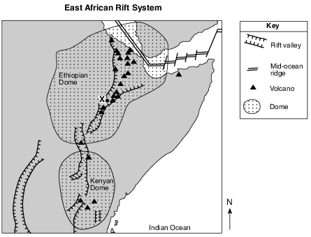
    Which two lithospheric plates are separated by a mid-ocean ridge in the northeastern portion of the Ethiopian Dome? [1]

    Plate and _____________________________ Plate

    Allow 1 credit for Arabian Plate and African Plate.